Article
The Smartphone as urban mediator and ‘sixth-sense’
A new platform for recognizing and acting upon the signals of the city. Article presented at the 14th Meeting of the AESOP Thematic Group on Planning and Complexity, Bamberg, Germany
Introduction
Cities have always offered a variety of signals that allowed people the means to sense patterns within the urban environment and change their behaviors accordingly. Our visual senses, triggered by signs of urban decay, warn us to avoid unsafe streets; our auditory senses, triggered by the sounds of church bells ringing, are reminded of the time of day; our tactile senses, registering the heat of the sun or the chill of the wind, cause us to seek shelter under an urban canopy, or cross a street to take advantage of the sun. These signals often register unconsciously but nonetheless cause us to act – redirecting our movement trajectories, increasing our propensity to inhabit certain areas versus others, and altering the dynamics of the city.
This paper considers how a new mediating device - the smartphone - is altering people's ability to register the signals emitted by the city. It further considers how this ability, in turn, alters the modes and patterns by which we inhabit urban spaces. Smartphones are able to detect patterns of urban living and dynamics (collected by means of big data) and represent these patterns through various ‘apps’ that process the gathered information. As smartphones becomes increasingly ubiquitous in people’s day-to-day lives, they act as a new ‘spatial media’ (Crampton, 2009), steering people’s engagement with the city. This mediating device allows people to sense patterns previously too faint or distant to register, distill those patterns that are useful, and thereby make actionable new behaviors that respond to the information received.
Complex Adaptive System (CAS) theory can be used to understand processes involving the coordination of many individual agents, the broadcasting of signals, feedback loops, and the emergence of patterns. As multitudes of individuals equipped with smartphones register previously invisible civic signals - and alter their spatial trajectories accordingly - their actions in turn create new signals that are relayed to others: thereby producing reinforcing feedback. We therefore employ aspects of Complex Adaptive System (CAS) theory to analyze how the smartphone shifts the ways in which meaningful places emerge through self-organizing processes. CAS theory is also ideal for studying systems that organize from the bottom up. We argue that the growing use of the smartphone as a means to understand and navigate the city marks the transition from top down and hierarchically controlled civic systems, to a much more bottom-up, nimble, adaptive and complex means of engaging civic life. The smartphone has the capacity to increase individual awareness of pertinent civic dynamics, amplify useful patterns of interaction, and generate emergent urban phenomena.
Part 1: Big Data, Individual Hands:
Physician John Snow was perhaps the first to recognize how the signals provided by individual data points could be aggregated to highlight emergent patterns. Through the mapping of illness sites associated with the Cholera epidemic in 1854 London, he was able to pinpoint the source of the disease to one particular water well, and use this information to halt the spread of illness. This early use of data mapping sets the stage for our modern enthusiasm for data analysis and the discovery of patterns associated with this data. Today, we have come a long way from the modes used by Snow. The proliferation of smart city protocols, transparency measures, and the Internet-of-things are all increasing the availability not just of data, but of Big-Data. This data, amassed at a huge scale and collected through networks of sensors, can be used to detect and interpret patterns regarding how environments and their inhabitants interact, produce, and live.
Until recently, Big Data had, for the most part, been collected and controlled by governments and corporate entities wishing to optimize particular processes. These entities held little interest in granting public access to their databases. Where access was granted, it was generally in aggregate form, making it difficult to analyze and process by individuals. Policy shifts, including national transparency measures, gradually began to make this centrally collected data increasingly open and public. In recent years, political "shows of faith" (with transparency and open government policies) have coincided with a growing numbers of political constituents beginning to see the value of this information. The availability of government data has been further fostered by Freedom of Information Acts, mandating the release of data in standardized formats. In addition, a growing number of private data sets are being made available in public repositories. Finally, the quality of data is now being monitored by government and media watchdogs and lobbying institutions, with the rise of ‘progress report cards’. At the time of writing, almost all fifty states and the Federal Government of the United States, along with many of the American and Western European countries, offer public data through open repositories and platforms such as Socrata, ESRI, or open-source options such as the GOV.UK project.
With data becoming increasingly available, and the costs associated with acquiring this data becoming free, data is now positioned to be placed into the hands of civic inhabitants Crowd-sourced data can be geo-located through the smartphone, by means of its integrated sensors that include GPS, accelerometer, compass, camera, and gyroscope. Data collection has thus shifted from operating as a closed and top-down process, towards being a more decentralized, individual, and interactive system. This means that the power over the control of data has shifted: governments and institutions are no longer the sole collectors and consumers of data. Today, bottom-up crowd-sourced data collection eclipses that which is performed by top-down entities. With the proliferation of the Internet, Broadband access, and the standardization of programming environments and protocols within the web, the initial investment needed to acquire, generate, and process data has been reduced to the point where anyone with a computer or smartphone is able to sense and collect data on city patterns and create apps for its analysis and utilization. Drawing from this broad range of open data sources, new apps are now being developed with an extremely low initial investment, making a broad range of information about civic patterns widely available to the general public. These make real time and location specific information about civic patterns intuitive and actionable.
As the awareness of data moves from top-down entities (governments or service providers), into the bottom-up hands of multiple players (the individuals using civic amenities), the choice to act upon the patterns relayed becomes subject to the will of multiple versus singular players. This increases the number of variables and the number of possible patterns that may be deemed as being important and actionable – making the overall patterns subject to much more complex dynamics.
Part of this complexity derives from the fact that smartphones not only gather static information, they also relay information that we produce in response to this data. Our actions thereby feed into the system, increasing the quantity and fidelity of signals, while offering the chance for patterns to be reinforced through feedback loops. Thus, “action taken with it on a micro level is itself new information that in turn informs what everyone else sees on a macro level” (Bratton, 2009: 94). To illustrate, traditionally, when traffic obstructions or accidents occurred, or special events caused traffic delays, people would stick to their normal behaviors – responding to the normal cues of the dominant road infrastructure - and the traffic jam would continue to worsen. Today, applications like Waze can sense crowd-sourced emergent patterns, including changing traffic flows, lane closures, hazards, or police speed traps. The patterns that are generated cause the app to re-calibrate the ‘fitness’ of different routes and plot new courses towards user-defined destinations. Often these courses follow non-traditional pathways that would normally never be ‘sensed’ as viable. But these apps are able to both sense the state of the city (traffic delays on major routes), and register alternatives (minor routes that were traditionally ‘non-visible’ to user consciousness). However, if the app starts directing too many people to take the same route (which then becomes overcrowded), new data regarding the overcrowding will in turn re-calibrate the system to move towards yet another alternative.
2. Shifting Pattern Perceptions, New Actionable Behaviors:
The careful observation of the composition of civic dynamics and patterns helps individuals to navigate the city. Kevin Lynch was one of the first to analyze how individuals use spatial cues in order to ‘get their bearings’ within the civic realm and navigate within that context. Lynch identified the various urban features - landmarks, paths, nodes, districts, and edges – that provide visual cues to help people mentally map their location within the greater urban context. Part of this navigation entails an understanding of spaces that exert ‘pull’ by affecting the senses through their hierarchical signaling: a tall tower draws us in, an open space within a dense urban network causes us to pause within the specificity of that node, a strong edge suggests a boundary that may feel threatening to cross. We subconsciously attribute places that signal difference – those marked by visual scale or other forms of visual hierarchy - as being special moments within the urban fabric. Similarly, our visual sense of boundaries (Lynch’s Edges) helps us to define regions that we regard as either ‘inside’ our territory, or ‘outside’ and belonging to the other. Our tendency is to remain within the charted territory of ‘insidedness’, and gravitate towards places that announce their importance within this territory through visual cues.
The patterns that Lynch captures within his methodology are relevant for decision-making within the city that occurs at the local level – helping determine whether one turns left or right at an intersection, depending upon the visual cues that steer decision-making. But other, more subtle patterns can be detected if one is able to parse together data about the city in aggregate form. Consider, for example, the location of urban commercial attractions. Traditionally, the discovery and promotion of businesses has been connected primarily to location, with bars, restaurants, and clubs being located in busy economic zones and near cultural hubs or attractions. Thus, people tend to gravitate towards consumer-centric economic areas of the city, and businesses vie for locations in close proximity to these zones. Prime business sites tend to cluster near Lynch’s Landmarks or Nodes, and individuals naturally gravitate to these locations in response to the wayfinding cues these spatial anchors provide.
Similarly, in seeking accommodation in a strange city, spatial cues regarding viable spaces to stay tend to be based upon gravitating towards either dense downtown districts (of urban hotels), or shifting to edge condition offerings (hotels near interstate nodes). Individuals ‘find’ these locations based upon visual cues: billboards along highways indicating appropriate exits, or signage on tall hotels located in downtown districts.
The functionality of these physical cues is predicated upon them holding a significant enough visual presence in the landscape to attract attention. This puts restrictions upon the number of actors able to leverage this presence: only those players with big enough pocketbooks have tended to be able to maintain significant physical manifestations of their presence within the broader sensory realm. At the same time, these large-scale actors have tended to market themselves towards the most neutral demographic possible: appealing to the average and the normative. Accordingly, the number of urban offerings traditionally perceivable are those offering largely generic appeal (witnessed by the dominance of big chains).
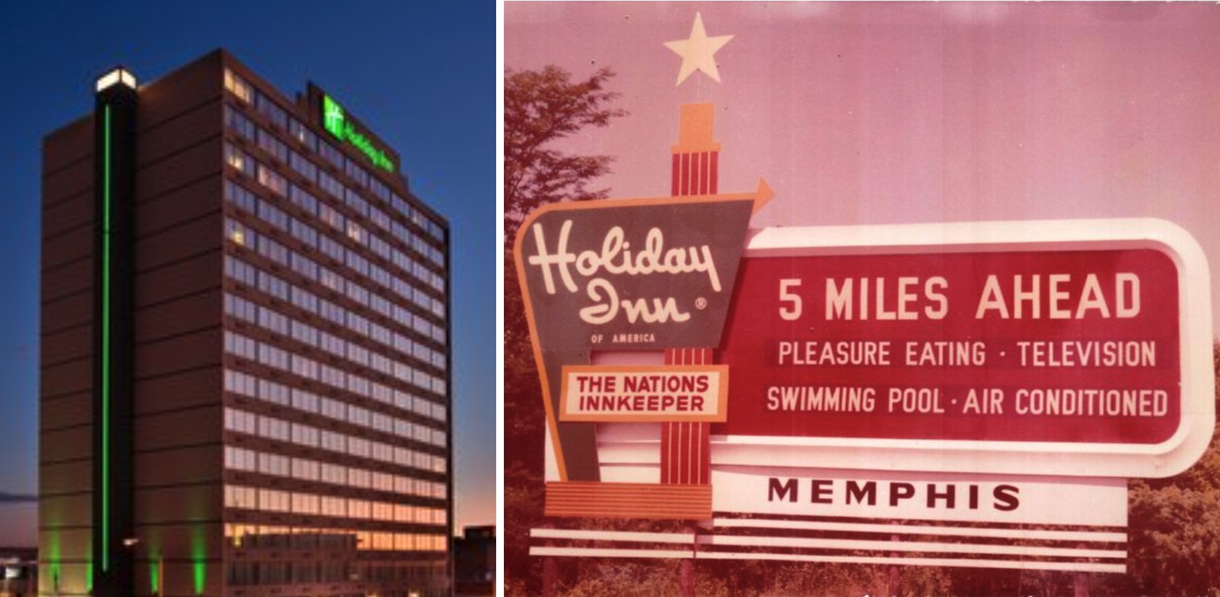
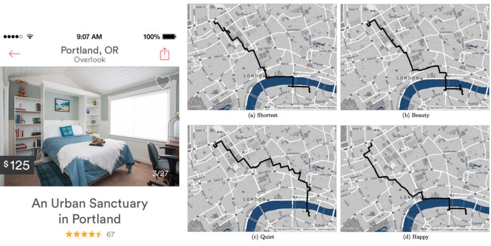
In the age of the smartphone these tendencies have the capacity to shift significantly. In the case of urban accommodation, platforms such as Airbnb allow users to discover urban situations that were not only previously invisible, but further constrained by an inability to verify their suitability due to the lack of trust systems being in place. To clarify, while Holiday Inn might not be the favored form of accommodation for all, it offers brand name recognition, and therefore a sense of safety and public endorsement. By contrast, a random posting for an inexpensive spare room advertised upon a bulletin board harbors no such sense of reliability or trust.
The ubiquity of the smart phone, and crowd-sourced data has changed all of this. Through web platforms such as Airbnb we can now discover a wide array of ‘made to order’ urban offerings that not only allow us to easily pursue customized needs (particular locations, price points, levels of sociability, amenities, etc.), but also to sense whether or not particular offerings are reliable (based upon the number and quality of ratings). This ability to have a highly intuitive sense of what were previously invisible urban amenities is shifting the ways in which we inhabit the city. Rather than gravitating towards Lynch’s physical nodes or landmarks, we can now discover virtual landmarks (those high-ranked spaces), that are no longer generic, but are instead tuned to respond to our particular desires (see Wohl, forthcoming).
In a similar way, the manner through which we move through the city can be customized based upon our individual priorities for navigation: be it speed, beauty, cost effectiveness, etc. For example, a project carried out by Yahoo seeks to determine which urban routes would be considered ‘emotionally pleasant’ based upon crowd-sourced data. Routing alternatives to get from point A to point B are analyzed through a series of metrics that moved beyond the default of ‘fastest route’. Thus, the ‘shortest route’ could be compared with the ‘happiest’, ‘quietest’ or ‘most beautiful’ route (Quercia et al., 2014).
Moving beyond the customized needs of the individual, the smartphone also has the ability to connect people of diverse backgrounds with similar interests. Social networks such as Yelp, Foursquare, Twitter, and Facebook allow users to alert friends and families of meet up locations. In using public APIs (application protocol interfaces) these networks use user location information not only to allow for check-ins but also to display popular places at any given moment near any given location. This data can highlight emerging ‘hot spots’ such as bars or club, allowing individuals to remotely identify which businesses are popular at any given moment in time. By knowing which places are ‘trending’, users can understand in real time which locations are the ‘place to be’ and alter their trajectories accordingly.
This information can be tweaked such that one is notified (through smartphone alerts) when a particular social event is occurring that is in sync with individual preference. The phone alerts one to a useful signal that would otherwise be invisible, and these signals are tuned to specific user desires rather than the cluttered by the ‘noise’ generated by only the most popular events for normative demographics. To illustrate, during the 2014 FIFA World Cup, apps were developed to signal which games would be shown at particular bars and pubs. The apps collected user preferences regarding their favorite teams and players, and would then notify them when bars within their vicinity would be showing relevant games. These apps, combined with using check-in data from Yelp, Foursquare, and Facebook, could turn a normally quiet sports bar into an active space geared specifically to cheer on the Costa Rican team. The ability for fans of this particular team to find one another, and merge into one specific geographic location truly begins to alter how we conceive of perceiving and acting upon the patterns of living in the city. We now have the means to wayfind in a manner that is in sync with our specific desires and propensities.
In our own work, we have been exploring a variety of web-based tools that would help steer urban behavior by highlighting invisible trends. For example, in 2015 one of the authors developed an app prototype called ‘Time for Lunch’ geared towards hungry university students. The app provided a means to see where fellow students were grabbing take-out lunch in the university vicinity, and then place orders with those students (who would receive payback credits for this service). The delivery system allowed people to place an order for cuisine at specific locations, and then orders could be ‘claimed’ by another individual who either had the desire to obtain the same cuisine or the means to physically retrieve said cuisine. As order requests were placed for given locations, students with the time/interest to grab lunch off campus (and pick up orders for others) would gravitate towards these locations, and since wait times for order retrievals would be lower at these sites, more students would, in turn, place their orders at these ‘emergent’ take-out locations. The app provided a viable alternative to the limited on-site lunch locations, but also demonstrated how different lunch hot-spots would emerge as a result of feedback loops generated in the interaction created by placing and retrieving orders.
The significance of this sensorial connectivity goes beyond daily convenience. In recent populist uprisings it has been the smartphone that has acted as the primary spatial coordination device: amassing citizens in protests, providing individuals with real time information on where police were cracking down, or where medical aid (to assist tear-gassed activists) could be obtained. Scholar and activist Jeffrey Juris, for example, discusses the ways in which smart devices were implicated in directing his actions during the #Occupy Boston movement. In orienting himself in space, he describes how, “my Android phone indicated a large group of protesters was on its way from the #Occupy Boston camp at Dewey Square and would soon turn a nearby corner…minutes later... I eagerly jumped into the crowd and joined in chanting.” In addition to prompting physical actions, images and tweets of activist events were captured on smartphones and circulated via social media, helping mobilize further activism in ways that the mainstream media (which authoritarian governments can manipulate in order to limit what is ‘sensed’ by the public) could not do.
These examples all point to the means through which our day-to-day inhabitation of the city can be redirected in ways that help us access civic amenities, circumventing normative or hierarchically imposed routings.
An amplified sense: the smartphone as bodily extension?
We wish to make the claim that the ubiquity of the smartphone as part of our day-to-day lives marks a sea change in how we intuit the world around us. The phones, now carried by half the world’s population in rich and poor countries alike, are not simply a means of looking up data or staying in touch with one another. For the billions of young people who carry phones on their bodies at all times of the day, the phone behaves as a material extension (Ihde, 1975) of their beings, one they continuously engage with as they navigate through temporal and spatial situations. Admittedly, for those in older generations this extension is not so acute. There are those of us who still consider the phone as something that we employ, on occasion to make calls, or to look up information that we once obtained through maps or other sources. But for the younger generation, growing up in the age of the Internet, the phone is not simply another tool that is employed on an as-needed basis. It is instead a necessary corporal extension – the removal of which (as any parent knows) is considered an impairment to existence. For this generation, “the iPhone does not feel like a desktop or phone experience, but instead something immediately recognisable as a personal interface to ambient information… embodied by tangible interfaces activating living information in the here and now.” (Bratton, 2009).
The phone, with its pervasive contact with our bodies – vibrating notifications, or alerting us to information with its pings – becomes a sensory prosthetic that we rely upon from the moment we awaken till the moment we close our eyes to sleep. Its ‘pervasive presence’ (Leszczynski, 2015), enables us to perceive the world in an intuitive manner that imbricates human and machine as co-entities, moving beyond the reach of the normal sensory apparatuses. Thus, “for contemporary citizens, the act of reading, filtering, and interpreting the city is increasingly performed by software…in such technologies, the perception and navigation of geospatial volumes often seem to be less a factor than the perception and navigation of screen interfaces and databases” (Hamilton et al., 2014). In this reading, whereas, “the legible city waited to be read, the transparent city of data waits to be accessed” (Hamilton et al., 2014).
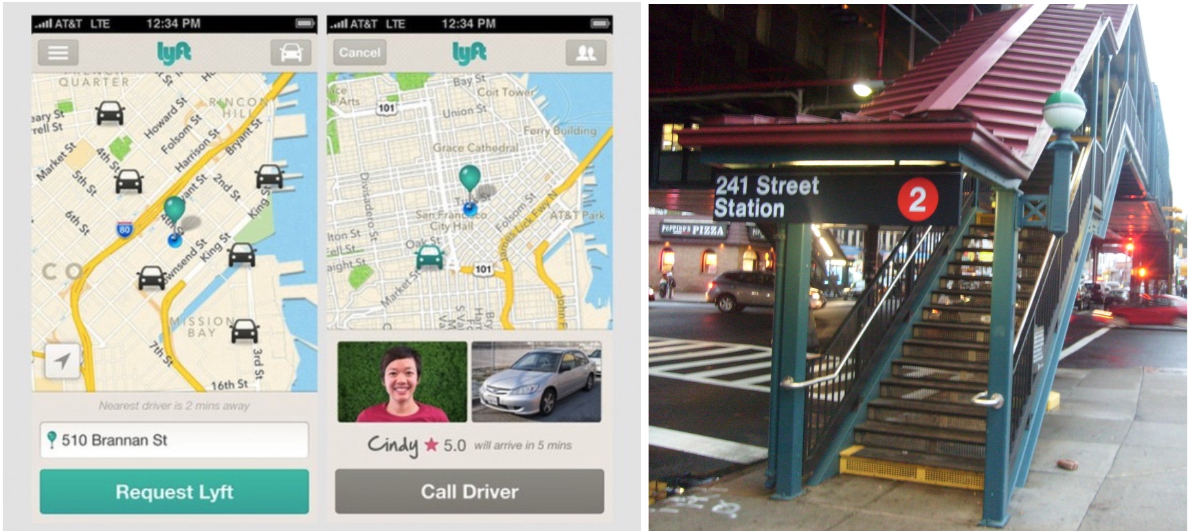
The real time connection to data about remote environments shifts our sense of personal bounded space, distorting notions of proximity and distance: a bar forty blocks away that we can pick up as ‘trending’ and for which we can source a nearby ‘Uber’ becomes sensorially more accessible and desirable then a downtown bar (perhaps only a metro stop away) that we may have ‘heard’ is popular. In this example, the static and fixed infrastructures designed for normative trends of movements become redundant in light of much more nimble and adaptive systems – the Lyfts or Ubers - that carry flows. In this scenario, new viable options of movement are created to experience the city. Lynch’s paths – which have an inherent hierarchy that directs our sensorial choices - are now traced not through visual orientation, but through app systems that choose pathways based upon real-time information about driver availability, time comparisons and costs. These pathways are not static: they change over the course of the day, in accordance with the shifting resources available to get us to our destination, as well as the shifting nature of the destinations themselves. The city becomes fluid, indefinite, modifying itself in accordance with a landscape of offerings that is now no longer limited by static and rigid forms of inhabitation. In this context, as Nigel Thrift describes,
“‘environment’ no longer describes a set of static co-ordinates forming a frame within which bodies move but a continually changing tableau in which bodies appear to have motility and which therefore has the ability to redefine itself in real time. The fixed frame becomes a continually unfolding, fluid and convective map of different kinds and rates of movement…”(Thrift, 2014: 10).
Self-organizing Feedback Cities: The implications of crowd-sourced sensing
Complex Adaptive Systems are ones that involve many actors, foster interaction or information exchange amongst the actors, and enable the emergence of global patterns or structures that are uncoordinated by the actors involved, but which in turn exert an influence upon subsequent agent interactions (feedback). CAS are complex in that the dynamics of the system operate in a non-linear fashion: a small change in initial conditions of the system can lead to wildly divergent outcomes in terms of the behaviors that the system manifests. Thus, unlike systems governed by linear, Newtonian dynamics of clear cause and effect, the overall behavior of the system cannot be accurately predicted based upon linear assumptions (forces, trajectories, etc.). Laplace’s demon is here unsettled as the world becomes essentially unknowable. Instead, CAS dynamics unfold following numerous divergent trajectories, and the role of science is constrained to learning about the potential range of trajectories (phase space), the kinds of behaviors that tend to play out (basins of attraction), and the ways in which behaviors are structured or steered (evolutionary processes). Further, the environment in which the agents operate is both a result of agent interaction, and a factor that predicates and constrains subsequent agent interaction in an ongoing dance of agent/environment co-evolution. Finally CAS behavior is effectively steered from the bottom-up versus the top-down. As such, CAS research requires a shift in how we think of effective organizations – given that highly ‘fit’ and tuned behavioral patterns are able to emerge without the top-down organizational control that we associate with generating efficiencies.
The smartphone, as a mediating interface, supports CAS processes through its ability to coordinate the actions of many individual agents, broadcast signals, allow for feedback processes, and foster emergent civic dynamics. In this new ‘sentient city’ ((Thrift, 2014), “an awareness starts to arise which invents the means to submit to its own requirements, to activate its own activation” (Thrift, 2014: 12). This shift towards citizen-sensing enables the transition from a linear system of data collection – that essentially involves action and reaction, to a much more subtle and complex system. Thus, as pointed to in the examples cited earlier, not only are invisible sources of urban amenities highlighted through the amplified sensory capacities of the smartphone, but those offerings that prove popular are subsequently reinforced over time: altering the dataset - and the cityscape - in ways that generate reinforcing feedback loops. Rounds of feedback loops amplify initial slight signal variables, resulting in the fact that even subtle shifts in initial conditions can now cause hugely divergent actions (following non-linear trajectories).
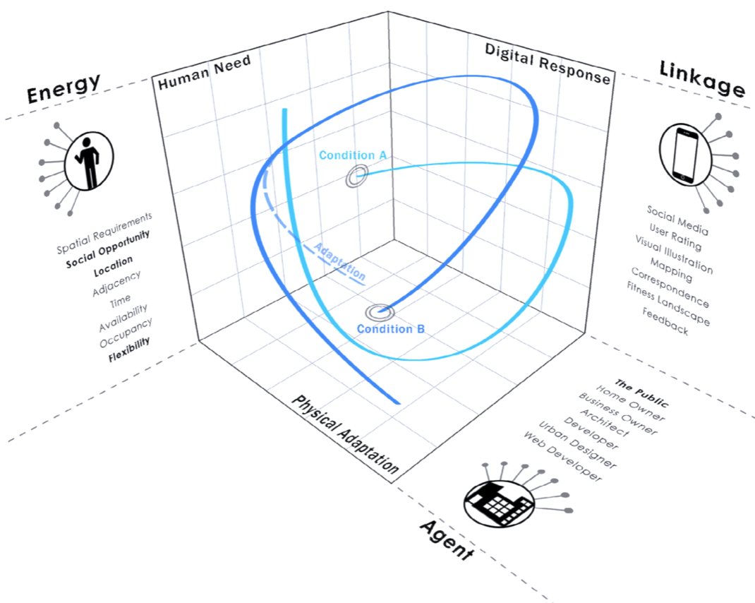
Image by Brandon Fettes (3)
With the advent of the smartphone as extension of our bodies, our senses, there suddenly emerges the chance to find exactly what we want, rather than what has been placed before us. This era of ‘ambient findability’ (Morville, 2005), constitutes a new disposition to the world where, “information is in the air, literally. And it changes our minds, physically” (Morville, 2005). Kevin Hamilton and his colleagues also note this shift, outlining how in the digital era, Lynch’s principles of civic legibility do not evaporate, but instead take on new, algorithmic and virtual forms (see Hamilton et al., 2014). They argue that,
‘A traveler’s “inputs” to such an algorithm might include not only searched-for destinations and travel histories, but records of previous decisions to deviate from paths. The paths of others in a user’s social network might also function as inputs to these processes. As users begin to notice such algorithmic structures, either through direct observation or media coverage, might they not begin to change their behavior to achieve desired outcomes?’
While Hamilton’s research team stresses that understanding the nature of the algorithms at play is key to understanding how particular spaces come to the fore of our attention, they makes no mention of the CAS dynamics that govern these processes. We believe that in order to appreciate the impact that an expanded sensorial awareness brings to the city, it is necessary to move outside an object oriented view of the city - one that understands civic environments as static entities that are stabilized in space and can shift only slowly in time - to instead consider cities as dynamic systems in non-equilibrium –that constantly evolve with their users and are constituted by fluidities of changing densities and kinds of information.
CAS dynamics enables such a reading. Instead of the stable equilibria of the ‘downtown business district’ or the central square and plaza, CAS allows us to think of the space of urban unfolding as occupying a multitude of potential points in phase space, a phase space that congeals and thickens at particular locations in particular moments in time (Jones, 2009; Wohl, 2015). These moments in time become periodic rather than stable attractors, and their periocity shifts in accordance with the population and intensity of the actors activating the system. The more energy, the more opportunities for bifurcations into multiple trajectories of unfolding, each of which has its own specificity, its own customized engagement with the resources the civic environment can offer. In this city, it is not the only the key agents, the ‘big brands’ that dominate our senses. Rather, the ‘long tail’ of urban possibilities are opened to us - made sensible - in ways we never imagined possible. The smartphone acts as the binding link in this complex civic system– weaving together different locations, persons, and times, at the node of the personal body carrying the phone. These individual threads of connection carry different weight and thicknesses dependent upon the nature of the individual and their preferences. We diverge from the norm, the central path, and instead we construct the path, the uber-lift route, the ‘happy’ route that serves our immediate needs. These constructs – possibilities in phase space – were always there, but our ability to perceive them, trust them, draw upon their affordances was missing.
Discussion
With the use of the smart phone, information about the long tail is suddenly made sensible, immediate, proximate. In this sense the virtual (in its technological definition of cyber enabled or enacted space), activates the virtual (in its philosophical definition of pertaining to the capacities of an entity that may or may not be manifested depending upon context) (DeLanda, 2005). And by seeing forms and objects as not absolute, but rather contingent entities brought about through interactions, CAS provides an ontological perspective that can accommodate this virtual terrain, positioning urban entities as potential basins of attraction, never stable or permanent, but having the capacity to manifest according to feedback dynamics. As a user of the urban sphere is drawn towards a particular basin – pulled in by the gravitation of signals that were never previously felt – the pull of that site grows stronger. Whether this basin of attraction comes in the form of a bar, a café, a flash mob site, a calm route, its emergence as a ‘weighty’ niche within the urban fabric, one that manifests its presence, is now no longer predicated upon its static position within a pre-determined hierarchy. The presence of Lynch’s landmarks, nodes, districts, all evaporate as stable attractors and are replaced with much more contingent, variable and customizable offerings. Echoing research in Science and Technology Studies (STS), this framework suggests that mediating agents such as the smartphone enable a less static view of infrastructure as something that is not so much ‘given’ as ‘enacted’ in space. And this shifting infrastructure takes us to places that were not previously visible on our mental maps of the cities we inhabit.
Let us follow this stream of logic:
A teenager is visiting Paris for the first time. Numbed by the ubiquitous imagery of the Eiffel Tower, she walks past it obliviously, eyes glued instead to the smartphone while it tracks the emerging vectors leading to an Indie band’s pop-up gig. Her trajectory shifts, and she ignores the movements ahead that might, at an earlier time, have pulled her towards the Champs D’Elysees. Instead she follows her phone, heading onto a sidestreet where an Uber idles. An alert sounds, causing her to pause and reconsider her options. She has arrived at a bifurcation fork in the mediated virtual road. While the pop-up gig is attractive another Band is trending at a Club in the 12th arrondissement. Pausing to weigh her options she checks the reviews of this new Band and makes her decision based upon its marginally higher ratings. Pushing a notification in her phone she alerts her Parisian cousin as to her course, and they plot their rendezvous. Her cousin in turn notifies his friends on social media of his plans, amplifying the draw to the Club in the 12th. The reinforcing feedback loops initiated by this sequence of events in turn pull greater numbers to that site. The Pop-up gig location remains quiet – its niche appeal or ‘fitness’ is geared towards a similar demographic, and under slightly different initial conditions it might have become the strong basin of attraction, but on this particular night its capacities remain unrealized.
With what analytical tools might we understand this new form of urban occupation, one that is not predicated upon the physical forms we have become so used to focusing our attention upon? If we normally rely on mapping to help us understand urban dynamics, then how would we map this urban scenario? And what would that map contribute to future analysis, since it would capture a path, a trajectory, a node that remains so tenuous and contingent in its manifestation? Further, in this conceptual space that is populated not by stable landmarks but of contingent affordances, will stable basins emerge? Will the urban system have an enhanced capacity to probe a broader range of spatial trajectories, and then settle into patterns that are reinforced and proven to be ‘fit’ over the longer term?
These questions point to research beyond the scope of this paper. But what is clear to us is that the capacity to sense the city at a distance, to detect patterns and, by our actions, to modify and shape those patterns, alters the way in which we should be thinking and analyzing the urban realm in fundamental ways. In this conception, a city cannot and should not be ‘planned’ to support a single optimum configuration, but can instead be inhabited and experienced in multiple, individual ‘satisficing’ scenarios - each dependent upon the moment in time, and the actors involved.
Bibliography
- Bratton BH (2009) iPhone City. Leach N (ed.), Architectural Design, John Wiley & Sons, Ltd., 79(4), 90–97.
- Crampton JW (2009) Cartography: maps 2.0. Progress in Human Geography, 33(1), 91–100.
- DeLanda M (2005) Intensive Science & Virtual Philosophy. New editio. Continuum.
- Hamilton K, Karahalios K, Sandvig C, et al. (2014) The image of the algorithmic city: a research approach. Interaction Design and Architecture(s) Journal, 20, 61–71.
- Ihde D (1975) The Experience of Technology: Human-Machine Relations. Philosophy & Social Criticism, 2(3), 267–279.
- Jones M (2009) Phase space: geography, relational thinking, and beyond. Progress in Human Geography, 33(4), 487–506.
- Leszczynski A (2015) Spatial media/tion. Progress in Human Geography, 39(6), 729–751.
- Morville P (2005) Ambient Findability. O’Reilly Media.
- Quercia D, Schifanella R and Aiello LM (2014) The Shortest Path to Happiness: Recommending Beautiful, Quiet, and Happy Routes in the City. Proceedings of ACM HyperText.
- Thrift N (2014) The “sentient” city and what it may portend. Big Data and Society, 1(June), 1–21.
- Wohl S (2015) Considering how morphological traits of urban fabric create affordances for Complex Adaptation and Emergence. Progress in Human Geography.
Notes
- https://sunlightfoundation.com/blog/2013/03/11/openstates-report-card/
- Smart phone are forecast to be used by 4.8 billion people by 2017 (http://www.statista.com/statistics/274774/forecast-of-mobile-phone-users-worldwide/). Current global population is approximately 7 billion people.
- This image was generated for a course on complex adaptive systems at Iowa State University taught by Sharon Wohl. It is part of a research poster that was prepared by Jeff Givens for the course, and presented at the ‘'Design, Social Media and Technology to Foster Civic Self-Organisation” conference,held in 2015 in Hasselt, Belgium.
Photo Credit and Caption: Underwater image of fish in Moofushi Kandu, Maldives, by Bruno de Giusti (via Wikimedia Commons)
Cite this page:
Wittmeyer, S. (2020, 29 June). The Smartphone as urban mediator and ‘sixth-sense’. Retrieved from https://seanwittmeyer.com/definition/sixthsense
The Smartphone as urban mediator and ‘sixth-sense’ was updated June 29th, 2020.